The CDT is known as the
longest, most remote, and most challenging trail of the three big trails (PCT,
AT, CDT) that comprise hiking’s “triple crown” in the US. The trail was
established by Congress just four days after the day I was born in 1978.
Even though the trail is over three decades old, it is still incomplete and far
fewer hikers have attempted what is known as “The King of Trails.”
The slogan often used to describe the CDT is “Embrace the Brutality.”
This is because everything about the trail is said to be a bit more challenging
and unpredictable. Mainly, the navigation, terrain, weather, and water sources.
Since the trail is only 70% complete, there are areas where there could be extended walking on old dirt roads, no trail at all with cairns or trail blazes hundreds of yards apart to guide the way, or a faint path that might be right or wrong…Miles
can be more difficult to knock out when there is a less defined trail and most
of the hiking, which follows the Rocky Mountain Range, is between
10,000-13,000ft elevation. The trail’s name comes from the fact that
it mainly goes along the Continental Divide, which is the backbone of North
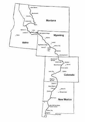
America. The CDT is said to be 3,100mi along the Divide, but the most favored route takes you on alternate routes that shorten the trail to about 2,800mi while taking hikers through some of the best scenery on the whole trail. Part of the adventure of the trail is choosing routes depending on your preference or dictated by timing and the weather.
Being on the Divide at high elevations, weather can be challenging with a large range of
temperatures and conditions that include desert heat, below freezing temps, and
the infamous thunderstorms and snowstorms. Water sources are few and far between on the Divide, so hikers must carry larger
amounts of water for greater distances. Many water sources are caches
maintained by trail angels or windmills that are primarily there to hydrate cows apparently… so needless to say water really needs to be filtered and treated before drinking! At this point, you might be
thinking that this trail does not sound appealing at all…Well, I think that this trail is evidence that sometimes the greatest challenges bring the greatest rewards…Check out these
amazing photos my friend, Coach K (who I met on the PCT), kindly
gave me as a preview to share of what is to come. He hiked the trail this past
year southbound, so the seasons are slightly different, but you will see why
many say this is the most amazing trail in the world! THANK YOU FOR THE PICTURES COACH K!!!
***If you
are viewing this on a mobile device, this slideshow may not appear and you will
need to view it on a computer.***
In recent years, the CDT
has gained momentum and more is being done to complete the trail and map it
more completely. I am fortunate in that each year, as more people hike the
trail, there are more resources and more detailed maps and waypoints. Just last
year the association for maintaining the CDT crumbled due to economic woes and
thankfully the Contintental Divide Trail Coalition
has formed over the past year and seems to be garnering some greater support.
With the trail being more remote and less people hiking or living near the
trail, it can be difficult to keep it maintained. For more detailed information on the trail, visit the website for the Continental Divide Trail Coalition.


