
Sponsors


Day 108: Finally Cruising!
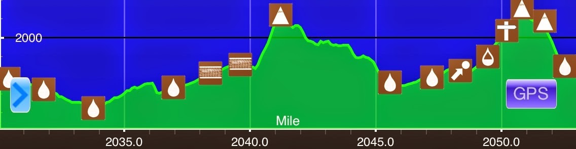
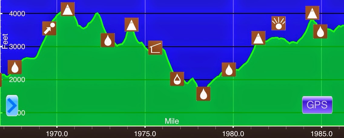
Sidney Tappan Campsite(2108.5)-Potaywadjo Spring Lean-to(2137) MaineAug 2nd28.5miElevation chart courtesy of Guthook's AT Hiker app. He has apps for many trails including the PCT and CDT.It did not rain overnight and was clear this morning, so that was a relief. The...

Day 107: The Unexpected Long Day
Long Pond Stream(2085.3)-Sidney Tappan Campsite(2108.5)Maine Aug 1st 23.2mi Elevation chart courtesy of Guthook's AT Hiker app. He has apps for many trails including the PCT and CDT. The rain from yesterday came to an end overnight and we thankfully got a dry day...

Day 106: Moseying Into The 100 Mile Wilderness
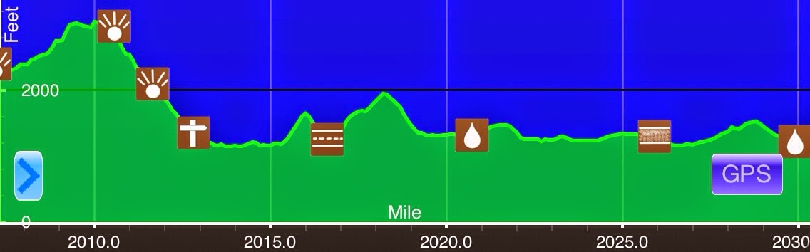
ME 15/Monson(2070.8)-Long Pond Stream(2085.3)Maine July 31st 14.5mi Elevation chart courtesy of Guthook's AT Hiker app. He has apps for many trails including the PCT and CDT. We had a great time at the Lakeshore House in Monson and were in no hurry to leave this...

Day 105: Monson, The Final Stop
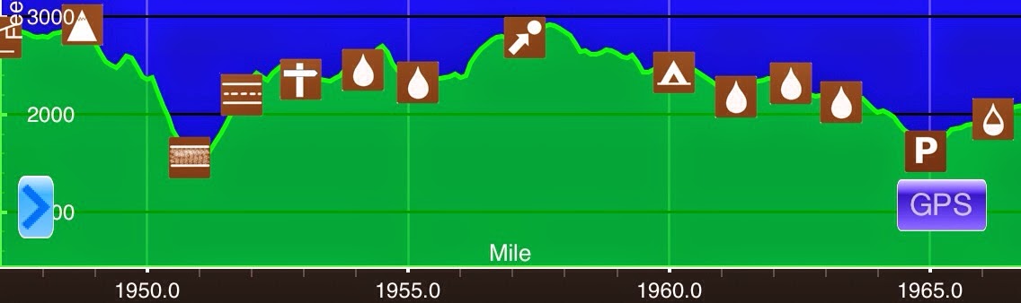
Moxie Bald Mtn Lean-to(2052.9)-ME 15/Monson(2070.8)Maine 17.9mi Elevation chart courtesy of Guthook's AT Hiker app. He has apps for many trails including the PCT and CDT. While we were getting ready this morning, an aggressive little chipmunk was running into our...
Day 104: Wet Feet
July 29th Pierce Pond Lean-to(2030.1)-Moxie Bald Mtn Lean-to(2052.9)Maine 22.8mi Elevation chart courtesy of Guthook's AT Hiker app. He has apps for many trails including the PCT and CDT. I got some pretty good sleep last night after the early evening thunderstorm...
Day 103: Hittin' The Ground Not Runnin'
July 28thSafford Notch Campsite(2007.5)-Pierce Pond Lean-to(2030.1)Maine22.6miElevation chart courtesy of Guthook's AT Hiker app. He has apps for many trails including the PCT and CDT.It did rain on and off through the night last night, but nothing too heavy. We awoke...
Day 102: Bigelow Bubble
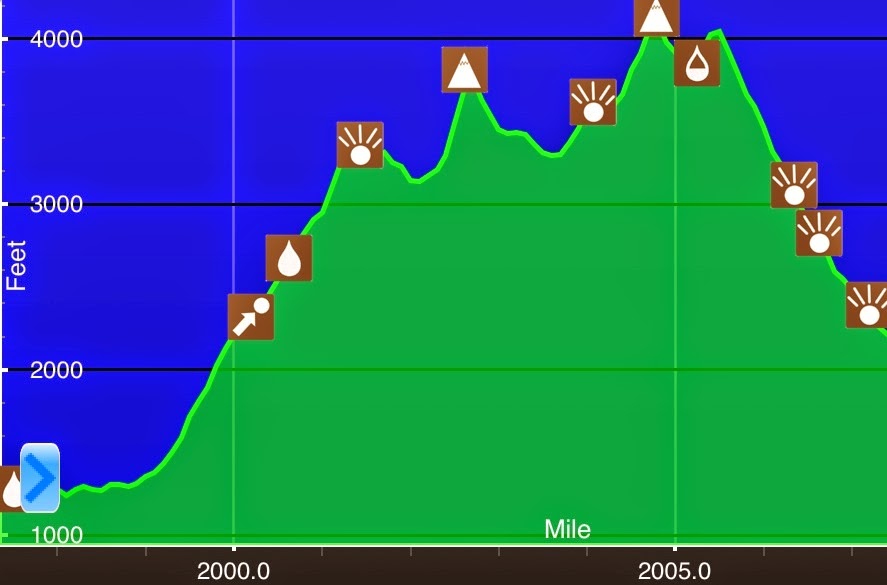
July 27th ME Rt 27/Stratton(1997.1)-Safford Notch Campsite(2007.5)Maine 10.4mi Elevation chart courtesy of Guthook's AT Hiker app. He has apps for many trails including the PCT and CDT. Despite being in a hotel, we were both awake at 5:30am. Squatch was staying in the...
Day 101: A Half Day To Stratton
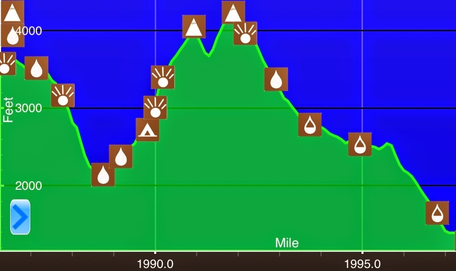
July 26thViewpoint S of Sugarloaf Mtn(1986.3)-ME Rt 27/Stratton(1997.1) Maine10.8miElevation chart courtesy of Guthook's AT Hiker app. He has apps for many trails including the PCT and CDT.Today was a town day after a six day leg with difficult terrain. We were...
Day 100: See The Watery Part Of The World
July 25thPiazza Rock Lean-to(1966.7)-Viewpoint S of Sugarloaf Mtn(1986.3) Maine19.6miElevation chart courtesy of Guthook's AT Hiker app. He has apps for many trails including the PCT and CDT.This is a long entry, but totally worth it...We woke up to a nice cool...
Day 99: Motivating Magic
July 24thBeamis Mtn Lean-to(1947.2)-Piazza Rock Lean-to(1966.7) Maine19.5miElevation chart courtesy of Guthook's AT Hiker app. He has apps for many trails including the PCT and CDT.We awoke to a nice cool foggy morning. Neither one of us was looking forward to putting...
Day 98: Maine In Rain
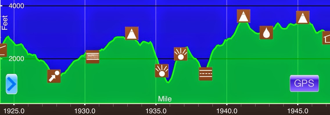
July 23rdFrye Notch Lean-to(1923.9)-Beamis Mtn Lean-to(1947.2) Maine23.3miElevation chart courtesy of Guthook's AT Hiker app. He has apps for many trails including the PCT and CDT.I didn't sleep as well as I had hoped last night. My body was ready to sleep, but my...
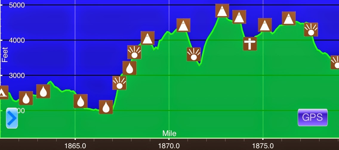
Day 97: Slow Motion
July 22nd Full Goose Shelter/Campsite(1908.4)-Frye Notch Lean-to(1923.9) Maine 15.5mi Elevation chart courtesy of Guthook's AT Hiker app. He has apps for many trails including the PCT and CDT. We awoke this morning to a nice sunrise through the trees. Today was the...
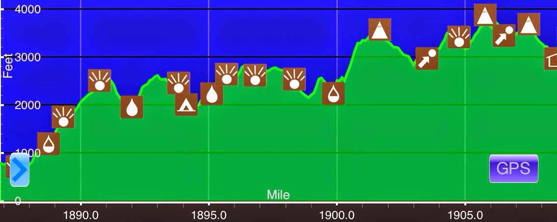
Day 96: Maine Baby!
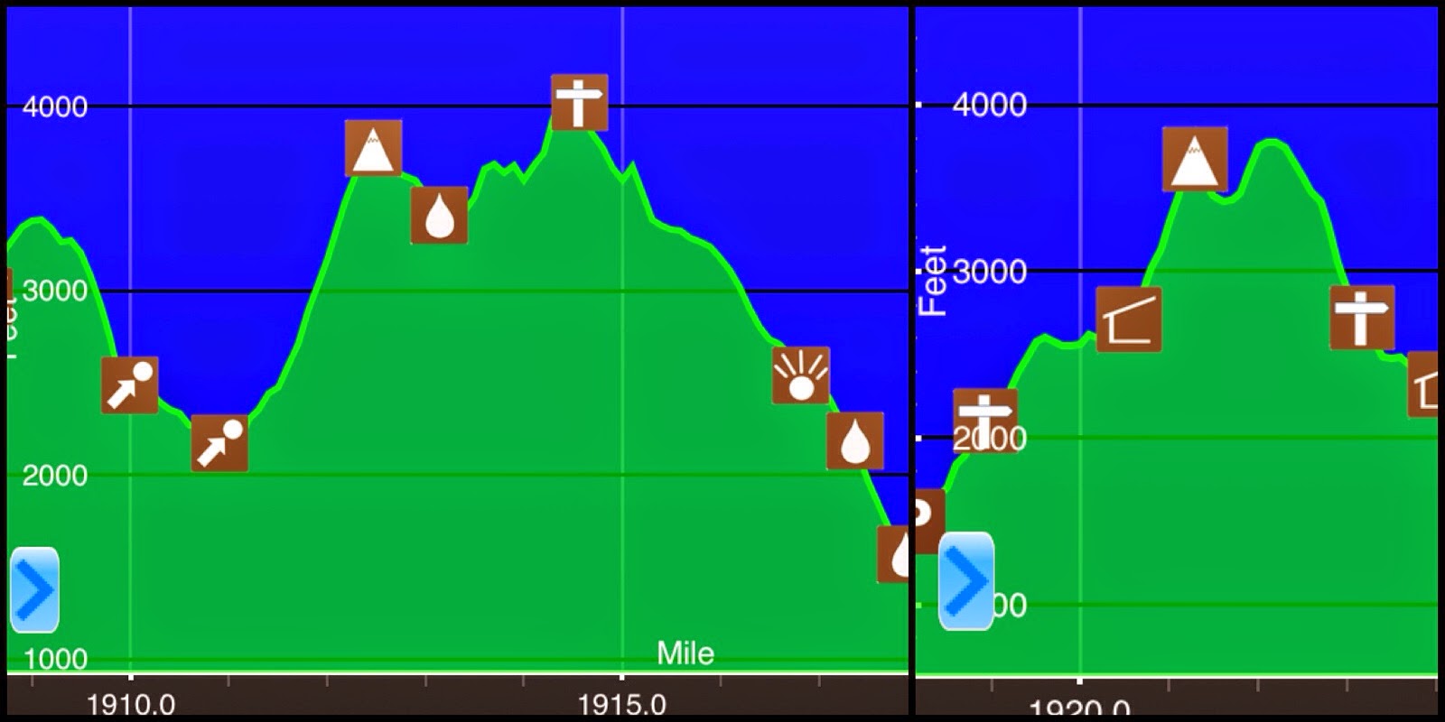
July 21st US 2/Swinja's(1887)-(Full Goose Shelter/Campsite(1908.4) New Hampshire/Maine 21.4mi Elevation chart courtesy of Guthook's AT Hiker app. He has apps for many trails including the PCT and CDT. I got way too distracted with socializing yesterday at Swinja's and...
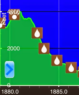
Day 95: Back To Swinja's
July 20th Imp Shelter(1879)-US 2/Swinja's(1887) New Hampshire 8mi Elevation chart courtesy of Guthook's AT Hiker app. He has apps for many trails including the PCT and CDT. Notice: For these final weeks through Maine, I may have less service, so the posts may get...
Day 94: Oops, We Did It Again
July 19th Osgood Tentsite(1861.2)-Imp Shelter(1879) New Hampshire 17.8mi Elevation chart courtesy of Guthook's AT Hiker app. He has apps for many trails including the PCT and CDT. I was awake just before 5am this morning and I could sense that Jett Cat was awake too....